Mera Peak Climbing Trek (A)
Day 01 POYAN (CHUTOK) (9186'/2800M):
Fly into Lukla and meet the Sherpas. Check all climbing gear then follow the path down the south side of the airstrip and descend steeply for half an hour before meeting the main trade route coming up from the south to the Khumbu. Continue the descent to Surke before climbing up to the Chitok La. There are more ascents and descents before arriving at a good campsite at Poyan.
Day 02 PANGKONGMA (9700'/2957M):
After crossing the Poyan Khola, we turn off the main route onto the old trade route climbing up to the ridgeline overlooking Khari Khola. Descend to Kharte and then leaving the main trail we start contouring to the east. Lunch will be by a subsidiary stream of Khari Khola. After lunch there is a steady climb up to the attractive farming and trading village of Pangkongma.
Day 03 GAY KHARKA (6560'/2000M):
Fine views west back to Trangsindo monastery. Lamjura and North West to Kwangde. A climb through thick rhododendron and bamboo forests leads to Pangkongma La (10400'/3175m) before an attractive descent to the small settlement of Shibuche. There are beautiful views from here looking south across the endless foothills rising each side of the Hinku valley and shortly after the descent begins MERA with its twin peaks and vertical south face come into sight at the top end of this most impressive valley. After lunch the trail needs care as it drops steeply for 1 ½ - 2 hours down to a small bridge over the Hinku Khola. It is then a tough climb up to Gay Kharka itself.
Day 04 CHALEM KHARKA (10496'/3200M):
Following up the south flank of the valley we pass other potentially good campsite on pasture land below Nashing Dingma (8300'/2500m). A deceptively long and steep climb leads to the Surke La (10200'/3085m). Shortly after this we pass the trail that leads east to Tumlingtar and East Nepal. We then follow another path leading to a small village called Cheskam. A third way up takes us across the slope. After 1 ½ hour climb we reach an attractive campsite set amidst rhododendron.
Day 05 Rest day/acclimatization.
Day 06 CHANBU KHARKA (13780'/4200M):
We follow the west side of the ridge before climbing through the last rhododendron scrub. The trail turns north climbing between two bluffs. Passing through more grazing country the route leads to a steep climb and a pass at about 12900'/3900m offering marvelous mountain views east right across to Kanchenjunga and Jannu and Hongo and Hinku villages. More hard work climbing up to around 14500'/4450m leads to an ill defined trail down to the banks of the main lake and camp.
Day 07 MOSOM KHARKA (12100'/3691M):
A steep climb leads out of the valley before the trail contours along and around towards the main Hinku Valley. This is followed by a series of steep descents, first westwards down scree then north west through scrub rhododendron and on into fir. A scrambling descent of around 2200'/290m brings us down near the valley floor where we cross the Mojang Khola and on through a bolder strewn forest to a lunch spot at Rondruk Dingma. After this the route follows along a fairly rough trail following the bank of the river to Mosom Kharka.
Day 08 GONDISHUNG (13300'/4060M):
Today we move camp only to Gondishung about 1 ½ hours further up to the valley. People can either have an easy day and relax or there is a very attractive side trip up to the Dhudhkund – a lake lying below the south face of Mera itself. The trail up the south bank of the Sanu Khola is well marked and it is about 3 ½ hours up from Mosom Kharka to the lake area itself. The views of the south face of Mera (21241'/6475m) and Naulekh (20870'/3636m) at the eastern end of the cirque of mountains makes all the hard work well worthwhile. About 2 ½ hours back down to Mosom Kharka and then 1 ½ hours up to the new campsite - a long, hard but rewarding day for those who wish for a good (acclimatization) side trip.
Day 09 DIG KHARKA (15200'/4660M):
The trail leads on up to Tangnag and then after lunch steepens up scree before turning east and gradually leveling off into the valley with the Mera La straight ahead and Mera Peak up and to the right.
Day 10 KHARE (16400'/5000M):
Acclimatization day which offers a worthwhile diversion/exploration trip towards the Hinku Nup Khare glacier. There are some alternative campsites in this area depending on conditions and whether there are other parties around the Dig Kharka area but it is best to move camp from the Dig Kharka up to Khare. Water can be difficult here. Much will depend on conditions at the time but in any event the afternoon should be kept free for sorting gear, checking crampons, etc. in preparation for the climb.
Day 11 HIGH CAMP:
From Khare a 1 hour a steep climb along a little winding path leads to a small high pass. It is then 15 minutes across scree to the tongue of the Mera glacier and a further 15 minutes scrambling up the side of the glacier itself before crampons etc. are fitted and the route moves out on to the glacier itself. It is about 1 ½ hours up to the Mera La (Pass) which offers fine views east and west. We will camp, high anything between ½ hour and an hour above the pass itself. In some ways, the higher the camp the better it is as it eases the climb the following morning.
Day 12 SPARE DAY:
This is built in as a spare day on the itinerary. However it the weather is good the decision will probably be made to make the climb this day.
Day 13 MERA PEAK (21192'/6461M):
The climb itself starts gradually and much will depend on snow and general weather conditions. The normal route steepness into a left hand valley before turning back and up a long sloping culvert that leads on up before finally emerging on a short ridge leading to a steep little climb up the exposed south east ridge to the summit. This section needs a rope fixed for protection. The climb takes approximately 6 hours from high camp. Descend back to Mera La.
Day 14 Chamlang Base Camp toward Baruntse BC 4 hrs .
Day 15 Panch Pokhari / Baruntse Base Camp
Day 16 Extra day at Baruntse BC
Day 17 Before Amphu Lapcha
Day 18 Cross Ampu Lapcha - camp before Chukung
DAY 19 Pangboche
DAY 20 Namche
Day 21 Lukla
Day 22 Lukla - Kathmandu fly out

Traditional Route to Mount Everest
The road from Kathmandu now extends as far as Jiri – almost into Sherpa country. The 7 hour or so drive is in itself interesting passing through diverse countryside, crossing the Sun Koshi River and climbing high over forested ridges before reaching Jiri, which has become something of a boom – town since the road arrived.
The trail leads up the east ridge of the river through Tamang villages, to Kharubas (8899'/2713m) and climbs through rhododendron forest, past old water mills and Mani walls to Buldara pass, marked by Mani walls. The path then descends to Chyangma through forests of rhododendron and oak, passing a large Chorten. A beautiful valley marks the entrance to Sherpa country. The village of Chyangma has some Tamang and Newar people but is predominantly Sherpa. Mani walls welcome travelers to the town. An interesting shop displays Sherpa Chang bottles and tea churns, essential in Sherpa home. We continue past the main village to a grassy field campsite.
The trail then takes us on a steep descent through the forest and after this more gradually past terraced fields to Phedi, a small Chettri settlement. We cross a suspension bridge and walk along the river to Kenja, a village whose population is a combination of Sherpas, Newars and Chettris. This junction is a bustling town with a primary school, tea houses and fabric shops. We then climb steeply through rhododendron forests with views to the south of the receding hills and lush valleys. Mani walls mark the entrance to the monastery village of Sete, the first Tibetan Buddhist monastery on the Everest trails. A visit to the hilltop monastery is worthwhile. 6 hours.
The trail takes us on a climb up to the Lamjura Pass, through pine forests, where trekkers are met by a mass of color (in season) as the pass ascends through a rhododendron forest. Some unnamed rocky summits at the head of the Rolawaling valley are visible from the pass. Lamjura marks a transition point between the receding hills to the southwest and the Solu Khumbu valley ahead. We then descend through rhododendron and pine trees to Thadobuk, a Sherpa village with a huge carved Mani rock. We continue down through fields of premolars down to Junbesi, a large Sherpa village with a chorten, large monastery and a school built by Sir Edmund Hillary. Here we can see a beautiful view of Number (22826'6959m). We camp near this very interesting village. 7 hours.
The trail climbs out of the Junbesi Valley and traverses high above the river valley to the east, the Solu Valley. A glimpse of Everest's summit is possible on a clear day. We continue along the ridge to Salung, past the Sherpa village of Ringmo Takshindu. (9800'/2933m). The chorten marking the top of the pass sets off the towering views of Kangtega (22235'/6779m) and Thamserku across the Dudh Koshi valley. We then drop down through the forest to the pagoda like monastery of Takshindu. 5 hours.
A steep descent takes us to Manidingma, a Rai and Sherpa village by a stream. The trail continues through Mustard fields and through forests where we have a chance of seeing langurs. The descent continues into the valley of the Dudh Koshi, which drains the southern slopes of the Everest Massif. After crossing a suspension bridge a gradual climb takes us to Jubling, a Rai village with bamboo stands around its houses. We continue to the Magar and Sherpa villages of Khari Khola. This is a village with water mills and mani walls and which has a colorful market every Wednesday. 5 ½ hours.
The trek then crosses Small River, before a steep climb to Kharte through rhododendron and oak trees as well as the fragrant danphe. We continue to Kartedara, through the forest where we have a good chance of seeing pheasant. A descent takes us to the river through rhododendron, birch, pine and bamboo areas to camp in the forest near the stream. 5 hours.
The trail continues to traverse high above the river from where we can get a fabulous view up the valley, including the airstrip at Lukla. This is followed by a long, steep descent to a small river at Surkya. We continue to the village of Chauri Kharka, set among terraces on the hillside. Our camp is near the bridge at Phakding. At the side of the bridge is a brightly painted mani rock,carved in commemoration of several families who died when Dudh Koshi became a raging torrent from an avalanche that originated high on the slopes of Ama Dablam.
Note:
On 5th August 1985 an avalanche of ice and rock falling into an ice lake above the village of Thame caused the lake to burst. The resulting flood greatly affected the Bhote Koshi valley, destroying bridges and the partially built hydro scheme below Thamo. It also destroyed all the other bridges and some of the routes down the Dudh Koshi as well as rolling over the massive boulder mentioned above.
The trail follows the Bote Koshi through forest and pasture, along a valley dotted with small backing trails to large Sherpa settlements. We cross the Bhote Koshi and climb steeply along switch-backing trail to large Sherpa village, views of Everest and Lhotse come to the sight. This prosperous town is the largest in the Khumbu and is a traditional trading center, which holds a bazaar every Saturday. The wares on display include grains and vegetables, tennis shoes and trinkets as well as hand woven aprons and Tibetan boots. Thameserku and Kwangle Ri loom to the east and west and the sacred mountain Khumbila dominates the skyline to the north behind the village. 6 hrs.
We traverse westwards with a view of Kwangde and the waterfalls cascading off its flanks. The path continues to follow the Bhote Koshi through yellow and white rhododendron forests which are in full-bloom in May. Crossing the river, we can look back down the valley at the beautiful views of Thameserku and Kusum Kanguru. We continue to climb up through rhododendron forest to pasturelands in front of the village of Thame. This secluded village is the birthplace of Tenzing Norgey, the first Sherpa ever to climb Mt. Everest. We will camp in meadows at edge of the village. Outside the village there is the Cliffside monastery which takes about an hour to walk but is of great interest. From here, we will climb across the ridge to view the route to the Nangpa La, a pass to Tibet frequently used by the Sherpas and their yaks during the monsoon. 6 hrs.
Today we walk back down the valley via Thamo, which is a hillside nunnery. We take the high trail, which by passes Namche and drops into Khumjung. This village is one of the most beautiful in Khumbu due to it symmetrically laid out stone houses where many Sherpa families live. The Sherpas may extend their hospitality and offer a teatime visit to one of their houses, which if offered is an experience not to miss. 6 hrs.
The trail descends from Khumjung with chortens framing a dramatic view of Ama Dablam and Kangtaiga flanked by the towering heights of Sagarmatha (the Nepalese name for Everest), Lhotse and Nuptse. We continue to descend through moss covered rhododendron forests, watching for blood pheasant and the Impayan pheasant in the undergrowth. After crossing the Dudh Koshi at Phungithanga we climb through rhododendron forests to the saddle at the top of the hill. Here lies Tengboche, the main monastery of Khumbu area, from which the views are unforgettable. Tengboche lies at the base of Kangtaiga and the spur of this ridge offers panoramic views of the main peaks of Khumbu including Everest, Lhotse, Ama Dablam, Twaoche and Khumbila. 5 Hrs.
The trek continues to descend from Tengboche and again we cross the Imja Khola to Pangboche, an interesting gompa site above the main village. Trekkers are in the midst of the Himalayas here, with spectacular views all around. For acclimatization there is a need to spend two nights around the 14,000'/4267m level and Dingboche, lying in a sheltered spot above the Imja Khola is generally more attractive than Pheriche. It is of note that the Himalayan Rescue Association have their aid post at Pheriche. 5 hrs.
A day's walk up to Chukung is highly recommended. The route gradually ascends to the few scattered stone huts that make up the settlement. To the south are ever changing views of Ama Dablam and to the north are the massive walls of the Nuptse ridge and the south face of Lhotse. Optional trip/hike to Chukung ri. 5 hrs.
The route traverses across the slopes over the ridge and stays above the village. It joins the trail below
ITINERARY
Day 01
The road from Kathmandu now extends as far as Jiri – almost into Sherpa country. The 7 hour or so drive is in itself interesting passing through diverse countryside, crossing the Sun Kosi River and climbing high over forested ridges before reaching Jiri, which has become something of a boom-town since the road arrived.
Day 02 BHANDAR (7200'):
The trail leads up the east ridge of the river through Tamang villages, to Kharubas (8899'/2713m). Climb through rhododendron forest, past old water mills and Mani walls to Buldara Pass, marked bu Mani walls. Descend to Chyangma through forest of rhododendron and oak, passing a large Chorten. Beautiful valley marks the entrance to Sherpa country. Village of Chyangma has some Tamang and Newar people but is predominantly Sherpa. Mani walls welcome the travelers to the town. An interesting shop displays Sherpa Chang bottles and tea churns, essential in a Sherpa home. Continue past main village to grassy field campsite.
Day 03 SETE (8450'):
Steep descent through forest then more gradually past terraced fields to Phedi, a small Chettri settlement. Cross suspension bridge and walk along river to Kenja at the junction of two rivers, a bustling town with a primary school, teahouses and fabric shops. The village population is a combination of Sherpas, Newars and Chettris. Climb steeply through rhododendron forest. View to the south of receding hills and lush valleys. Mani walls mark entrance to the monastery village of Sete, the first Tibetan Buddhist monastery on the Everest trails. A visit to the hilltop monastery is worthwhile. 6 hours.
Day 04 JUNBESI (8776'/2675m):
Climb up to Lamjura Pass, through pine forest. The trekker is met by a mass of color (in season) as the pass is ascended through a rhododendron forest. Some unnamed rocky summit at the head of the Rolwaling valley are visible from the pass. Lamjura marks a transition point between the receding hills to the southwest and the Solu Khumbu valley ahead. Descend through rhododendron and pine trees to Thakdobuk, Sherpa village with a huge carved Mani rock. Continue down through fields of premolars down to Junbesi, a large Sherpa village with a chorten, large monastery and a school built by Sir Edmund Hillary. Nice view of Numbur (22826'/6959m). Camp near this very interesting village. 7 hours.
Day 05 TAKSHINDU (9300'/2835m):
The trail climbs out of the Junbesi Valley and side hills running north and traversing high above the river valley to the east, the Solu Valley. A glimpse of Everest's summit pyramid is possible on a clear day. Continue along the ridge to Salung, a Sherpa village with small water-spun prayer wheels. Descend through pine forest and grassy slopes to the Ringmo Khola. Cross the river and climb through the apple orchards of the Sherpa village of Ringmo Takshindu pass (9800'/2933m). The chorten marking the top of the pass sets off the towering views of Kangtega (22235'/6779m) and Thamserku across the Dudh Kosi valley. Drop down through forest to the pagoda like monastery of Takshindu. 5 hours.
Day 06 KHARI KHOLA (6800'/2073m):
Descend steeply to Manidingma, a Rai and Sherpa village by a stream. Continue through Mustard fields and through forest, with chance of seeing langurs. The descent continues into the valley of the Dudh Kosi, which drains the southern slopes of the Everest Massif. Cross suspension bridge and gradually climb to the Jubing, a Rai village with bamboo stands around its houses. Continue to the Magar and Sherpa villages of Khari Khola, a village with water mills and mani walls which has a colorful market every Wednesday. 5 ½ hours.
Day 07 PUYAN (8800'/2603m):
Cross small river, then steep climb to Kharte through rhododendron and oak trees as well as the fragrant daphne. Continue through forest to Kartedara with a chance of seeing pheasant. Descend to river through rhododendron and birch, pine and bamboo to camp in forest near the stream. 5 hours.
Day 08 PHAKDING (8500'/2591m):
Trail continues to traverse high above river. Nice view up the valley, including the airstrip at Lukla. A long, steep descent to small river at Surkya. Continue to village of Chauri Kharka, set among the terraces on the hillside. Camp near bridge at Phakding. At the side of the bridge is a brightly painted mani rock, carved in commemoration of several families who died when the Dudh Kosi became a raging torrent from an avalanche that originated high on the slopes of Ama Dablam, a startling pyramid hidden by the steep walls of the valley above. Note: On 5 August 1985 an avalanche of ice and rock falling into an ice lake above the village of Thame caused the lake to burst. The resulting flood greatly affected the Bhote Kosi valley destroying bridges and the partially built hydro scheme below Thamo and also destroyed all the other bridges and some of the route down the Dudh Kosi – it also rolled over the massive boulder mentioned above.
Day 09 NAMCHE BAZAAR (11300'/3445m):
Follow the Bhote Kosi through forest and pasture land. Along a valley dotted with small Sherpa settlements. Cross the Bhote Kosi and climb steeply along switch-backing trail to large Sherpa village, views of Everest and Lhotse come into sight. This prosperous town is the largest in Khumbu. A traditional trading center, the Bazaar is held every Saturday. The wares on display include grains and vegetable, tennis shoes and trinkets as well as hand woven aprons and Tibetan boots. Thamserku and Kwangde Ri loom to the east and west and the sacred mountain Khumbila dominates the skyline to the north behind the village. 6 hours.
Day 10 THAME (12467'/3801m):
Traverse westwards with view of Kwangde and the waterfalls cascading off its flanks. Follow Bhote Kosi as trailside hills on its bank through yellow and white rhododendron forest (in full-bloom in May). Cross river, look back down valley for beautiful views of Thamserku and Kusum Kanguru. Climb up through rhododendron forest to pasturelands in front of the village of Thame. Secluded village is the birthplace of Tenzing Norgey, the first Sherpa ever to climb Mt. Everest. Camp in meadows at edge of village. An hour's climb to the Cliffside monastery is of great interest. From here, the trekkers can side hill above the village then climb across the ridge to view the route to the Nangpa La, a pass to Tibet frequently used by the Sherpas and their yaks during the monsoon. 6 hours.
Day 11 KHUMJUNG (12434'/3791m):
Walk back down the valley by way of Thamo, a hillside nunnery. Take the high trail, which bypasses Namche and drops into Khumjung. This village is one of the most beautiful in Khumbu. Its symmetrically laid out stone houses house the families of many of our Sherpas. The Sherpas may extend their hospitality and offer a teatime visit to one of these houses – an experience. 6 hours.
Day 12 TENGBOCHE (12670'/3863m):
The trail descends from Khumjung with chortens framing a dramatic view of Ama Dablam and Kangtaiga flanked by the towering heights of Sagarmatha (the Nepalese name for Everest), Lhotse and Nuptse. Descend through moss covered rhododendron forest, watching for blood pheasant and the Impayan pheasant in the undergrowth. Cross the Dudh Kosi at Phungithanga and climb through rhododendron forest to the saddle at the top of the hill. Here lies Tengboche, the main monastery of Khumbu area. The views from here are unforgettable. Tengboche lies at the base of Kangtaiga and the spur of this ridge offers panoramic views of the main peaks of Khumbu including Everest, Lhotse, Ama Dablam, Twaoche and Khumbila. 5 hours.
Day 13 DINGBOCHE (14150'/4412m):
Descend from Tengboche and again cross the Imja Khola then side hill gradually to Pangboche, an interesting gompa site above the main village. The trekker is in the midst of the Himalayas here, with spectacular views all around. For acclimatization there is a need to spend two nights around the 14000'/4268m level and Dingboche lying in a sheltered spot above the Imja Khola is generally more attractive than Pheriche. It is however of note that the Himalayan Rescue Association have their aid post at Pheriche. 5 hours.
Day 14 DINGBOCHE:
A day walk up to Chukung is highly recommended. The route gradually ascends to the few scattered stone huts that make up the settlement. To the south are ever changing views of Ama Dablam and to the north the massive walls of the Nuptse ridge and the south face of Lhotse. Optional trip/hike to Chukung Ri. 5 hours.
Day 15 LOBUCHE (16175'/4931m):
The route traverses across the slopes over a ridge and stays above the village. It joins the trail below Thugla, beautiful views of Cholatse (21129'/6442m) across the valley. After another steep ascent the trail climbs up and over the terminal moraine of Khumbu Glacier. Up and along the west lateral moraine of glacier the trail is rough in parts. Stark and rugged beauty creates almost a moonscape. Campsite at Lobuche a windswept collection of huts tucked in a narrow meadow between the glacier and the Lobuche Peak (20192'/6156m). Tawache and Nuptse are particularly spectacular from Lobuche, towering almost two kilometers directly overhead. 5 hours.
Day 16 LOBUCHE:
Early start essential. Travel along the Khumbu glacier through jumbled moraine and shattered rock. Climb Kala Pattar (5483m) for views of giants of the earth, Pumori, Everest, the Tibetan peak Changtse, Nuptse, Lhotse and countless other needle and snow fluted ridges. A trip to the actual Base camp of Everest is usuakky omitted. The Khumbu icefall obstructs views and the base camp are is littered with debris from years of climbing expeditions to Everest. And unless an Expedition is actually at base camp a route can be difficult to find.
Day 17 PHORTSE 3847m:
Descend gradually all morning. Pass through Pangboche. Stay high on the west bank of the river to the Sherpa village of Phortse, which lies on the lower southern flank of Tawache, directly across the valley from Tengboche. 6 hours.
Day 18 KHUNDE/KHUMJUNG:
Descend through forest to the Dudh Kosi, a very pretty crossing points leads to a steady climb to a chorten offering wonderful views back across the valley to Phortse, Tengboche and their surrounding mountains. A traverse leads to a classic descent down a giant rock pathway hewn out of the mount in side. A plod up the valley leads back to the twin villages. 5 hours.
Day 19 MONJO/JORSALE:
The route home leads back through Namche and off down the hill. There are some nice campsites close to the National Park boundary. 5 hours.
Day 20 Lukla 2804m:
From here the walk to Lukla take about five hours of which the last one and half are rather surprisingly hard work.
Day 21
One of the most thrilling take-offs in the world wings the Twin Otters high above the Dudh Kosi for the 45 minute flight back to Kathmandu.
Mera Peak Climbing Trek


Day 01 POYAN (CHUTOK) (9186'/2800M):
Fly into Lukla. Meet Sherpas. Check all climbing gear then follow down path on the south side of the airstrip and descend steeply for half an hour before meeting the main trade route coming up from the south to the Khumbu. Continue descent to Surke before climbing up to the Chitok La. Some more ups and downs before arriving at a good campsite at Poyan.
Day 02 PANGKONGMA (9700'/2957M):
After crossing the Poyan Khola turn off the main route on to the old trade route climbing up to the ridgeline overlooking Khari Khola. Descend to Kharte and then leaving the main trail start roughly contouring east. Lunch by a subsidiary stream of Khari Khola. After lunch a steady climb up to the attractive farming and trading village of Pangkongma.
Day 03 GAY KHARKA (6560'/2000M):
Fine views west back to Trangsindo monastery. Lamjura and north west to Kwangde. A climb through thick rhododendron forest and bamboo leads to Pangkongma La (10400'/3175m) before an attractive descent to the small settlement of Shibuche. There are beautiful views from here looking south across the endless foothills rising each side of the Hinku valley and shortly after the descent begins MERA with its twin peaks and vertical south face come into sight at the top end of this most impressive valley. After lunch the trail needs care as it drops steeply for 1 ½ - 2 hours down to a small bridge over the Hinku Khola. It is then a toughies climb up to Gay Kharka itself.
Day 04 CHALEM KHARKA (10496'/3200M):
Following up the south flank of the valley we pass other potentially good campsite in pasture land below Nashing Dingma (8300'/2500m). A deceptively long and steep climb leads to the Surke La (10200'/3085m). Shortly after we pass the trail that leads east to Tumlingtar and East Nepal and another one leading to a small village called Cheskam. We follow a third way up and cross the slope. After 1 ½ hours or so climb an attractive campsite set amidst and rhododendron is reached.
Day 05
Rest day/acclimatization.
Day 06 CHANBU KHARKA (13780'/4200M):
We follow the west side of the ridge before climbing through the last scrub rhododendron. The trail turns north climbing between two bluffs. Passing through more grazing country the route leads to a steep climb and a pass at about 12900'/3900m offering marvelous mountain views east right across to Kanchenjunga and Jannu and Hongo and Hinku villages. More hard work climbing up to around 14500'/4450m leads to an ill defined trail down to the banks of the main lake and camp.
Day 07 MOSOM KHARKA (12100'/3691M):
A steep climb leads out of the valley before the trail contours along and around towards the main Hinku Valley. This is followed by a series of steep descents first westwards down scree then north west through scrub rhododendron and on into fir. A scrambling descent of around 2200'/290m brings us down near the valley floor where we cross the Mojang Khola and on through a bulder strewn forest to a lunch spot at Rondruk Dingma. After the route follows along a fairly rough trail following the bank of the river to Mosom Kharka.
Day 08 GONDISHUNG (13300'/4060M):
Today we move camp only to Gondishung about 1 ½ hours further up to the valley. People can either have an easy day and relax or there is a very attractive side trip up to the Dhudhkund – a lake lying below the south face of Mera itself. The trail up the south bank of the Sanu Khola is well marked and it is about 3 ½ hours up from Mosom Kharka to the lake area itself. The views of the south face of Mera (21241'/6475m) and Naulekh (20870'/3636m) at the eastern end of the cirque of mountains make all the hard work well worthwhile. About 2 ½ hours back down to Mosom Kharka andthen 1 ½ hours up to the new campsite a long, hard but rewarding day for those who wish for a good (acclimatization) side trip.
Day 09 DIG KHARKA (15200'/4660M):
The trail leads on up to Tangnag and then after lunch steepens upscree before turning east and gradually leveling off into the valley with the Mera La straight ahead and Mera Peak up and to the right.
Day 10 KHARE (16400'/5000M):
Acclimatization day offering a worthwhile diversion/exploration trip towards the Hinku Nup Khare glacier. There are some alternative campsites in this area depending on conditions and whether there are other parties around the Dig Kharka area but it is best to move camp from the Dig Kharka up to Khare. Water can be difficult here. Much will depend on conditions at the time but in any event the afternoon should be kept free for sorting gear, checking crampons, etc. in preparation for the climb.
Day 11 HIGH CAMP:
From Khare 1 hour up a steep little winding path which leads to a small high pass. It is then 15 minutes across scree to the tongue of the Mera glacier and a further 15 minutes scrambling up the side of the glacier itself before crampons etc. are fitted and the route moves out on to the glacier itself. It is about 1 ½ hours up to the Mera La (Pass) which offers fine views east and west. A high camp is put in anything between ½ hour and an hour above the pass itself. In some ways the higher the better to ease the length of the climb the following morning.
Day 12 SPARE DAY:
This is built in as a spare day on the itinerary. However it the weather is good the decision will probably be made to make the climb this day.
Day 13 MERA PEAK (21192'/6461M):
The climb itself starts gradually and much will depend on snow and general weather conditions. The normal route steepens into a left hand valley before turning back and up a long sloping culvert that leads on up before finally emerging on a short ridge leading to a steep little climb up the exposed south east ridge to the summit. This section need a rope fixed for protection. The climb takes approximately 6 hours from high camp. Descend back to Khare.
Day 14
Rest day/spare day.
Day 15 TASHING DINGMA (11489'/3500M):
About three hours on down the valley lies Gondishung which used to be the site of an old monastery. A good spot for lunch. A little further down we pass a small bridge which was route used on the way in up the east bank of the river and continue on down the west bank. Entering rhododendron and fern forests there are some ups and downs before a good campsite is reached at Tashing Dingma. This is a long but not too strenuous day trek.
Day 16 TULI KHARKA (14760'/4500M):
The trail turns uphill and soon joins and follows the northern bank of the main stream. There was an spot for an early lunch after about one and half hours of consistent ascent where the stream is crossed. Water becomes more difficult later in the day. The ascent continues after lunch and we gradually climb above the tree line on to more broken and uneven ground. A day of almost constant ascent leads to Tuli Kharka.
Day 17 LUKLA (9184'/2799M):
The climb continues for about one and half hours up to the Zatrwala pass at 15000'/4560m. There are a series of chhortens and mani walls marking this pass which offers fine views across to Kwangde, Lumding Himal and Karyolung. Also views back east to the Poyan valley and across to our earlier route on the far side of Inukhu. The descent towards Lukla starts steeply down. There is an alternative pass at the Zatrwala Teng at about 16200'/4940m a little further north and if snow and weather conditions permit this might make an interesting alternative route back to Lukla. Chutenga is reached after about two hours which offers the first real spot for lunch-streams higher up are often dry or frozen. A good spot for lunch after a long morning. It is about another two hours down through the forest to Lukla.
Day 18 LUKLA – KATHMANDU
The trek ends with the spectacular flight from Lukla to Kathmandu. This takes 45 minutes and most flights operate during morning before the winds build up in the valley.
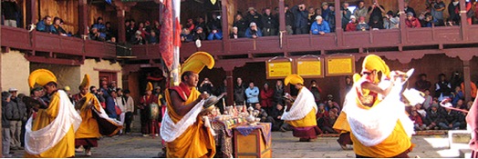
Mani Rimdu Festival Trek
The festive days of Mani Rimdu celebrate the completion of ten days of prayers of benefits of all beings.
The Story and Purpose of Mani Rimdu
The main purpose of Mani Rimdu is the prayers which worship Phakpa Chenrezig the god of compassion. His blessing brings peace and good fortune to everyone. During Mani Rimdu we invoke Phakpa Chenrezig's blessing on the rilbu, the long life-pills, and perform the dances which showing former times worship this deity.
Mani Rimdu is a fairly recent tradition in Khumbu. For the opening ceremony of Tengboche, Zatul Ngawang Tenzin Norbu of Rongbuk came to consecrate the monastery and the monks performed the dances here for the first time then. Since that event, Mani Rimdu continues at the same time of year. It used to be in the tenth month, but that was very cold for spectators and because of bad weather, difficult for preparation. Now, Mani Rimdu is held in the ninth month, unless a double month shifts it to the tenth.
Each sect and monastery have their own style of dancing. The dances at Tengboche came from Rongbuk. Before the Chinese came, these particular dances were done at Rongbuk, and started at Tengboche. Later, the lama at Chiwong gompa in Solu started Mani Rimdu there. When Thame became established as a celibate monastery, they started performing Mani Rimdu there also. It is held in the ninth month of Tengboche, tenth month at Chiwong and fourth month of Thame. There is no other identical Mani Rimdu anywhere else in Tibet.
When Ngawang Tenzin Norbu started Rongbuk, the Mani Rimdu ceremony there was also small but after more and more tawas came, they decided to have the dancing. They copied dances from other Nyingmapa gompas in Tibet and added some new dances that Ngawang Tenzin Norbu created.
In Tibet, this kind of festival is performed mostly in the fifth month, with the dances on the 10th day. It is called Tse Chu, and is the most important one of the year. A small Tse Chu is done on the tenth day of every month.
Almost every monastery has their own style of doing dancing, at different times of the year and special days of the month. The many different kinds of dances came from the many different movements described in the tantras. The Buddhist Newars also perform dances that came from the Tantra scriptures.
There are monasteries in other areas of Nepal such as Mustang, where they also do dancing, however the dancing is done only for a short time, not all day.
The name Mani Rimdu comes from mani the chant for Phakpa Chenrezig, ril the little red pellets and dub the blessing on the rilbu.
The blessing for the rilbu goes back to when Guru Rinpoche brought religion to Tibet. As well as Nyingma-kama, which he taught directly to the people, there was Nyingma-terma, which were teachings in books hidden for the future. Guru Ringpoche foretold that a time would come when wars and hard times would make the books necessary. The people who found these are the Tertons.
One of these, Tertak Lingba, whose full name was Gyurme Dorje Pema Karwang, found a hidden book called Thuje Chenpo Deshe Kundu. This book belongs to the Ogyen Mindroling College of the Nyingmapa sect and is read for Mani Rimdu. The Tibetan name Thuje Chenpo means Maha Karuna in Sanskrit, which translates as great compassion. Deshe Kundu is the specific name of this book. Thuje Chenpo is also a name used for Jigten. Wangchuk, the main aspects of Phakpa Chenrezig worshipped during the Mani Rimdu pujah.
This book is mostly about drubchen, a very powerful pujah body to invoke Phakpa Chenrezig.
Mani Rimdu starts on the first day of the ninth month with Sa-chog, the earth pujah to the gods of the four directions that consecrates the place where the pujah will take place. Thig-kor, the preparations of making torma and using colored sand to make the mandala, called the Dul-tson Kyil-khor begin the same day and continue until the fourth day.
From the fifth to the fourteenth days, the monks do the pujah called Ngo Zhi Cho-pa, that goes all day and night. In the morning the main pujah is to the action aspect of Phakpa Chenrezig, Lhachen Wangchuk, and then to the god Maha-kala, the protector of the Buddhist faith. Pujahs to other gods are done by turn, three one day, then three the next.
For the Whang, on the fifteenth day, people come for the lama's blessing and to receive the rilbu. On the sixteenth day, the monks worship Phakpa Chenrezig by dancing. There are sixteen dances. The dances aim to prevent interference, accidents, impediments, change of mind, faith, or hindrance by sin. The seventeenth day concludes with jinsak, a fire pujah.
The Blessing Ceremony
On the fifteenth morning, the tawas receive a blessing themselves and in the afternoon people come for the lama's blessing and to receive the rilbu.
There are many kinds of whangs, blessings, and this is a tor whang. Many torma have been made for the whang, in pyramids representing mandalas. During the whang, Ringpoche and the tawas visualize a mandala that cleanses the sins of the people so they may gain merit. They distribute the rilbu over which the mani has been chanted. The rilbu are chelab pills that generally cure or make the path after life a little easier. These rilbu contain relics from Guru Rinpoche's ter (spiritual treasures) that will bless our bodies.
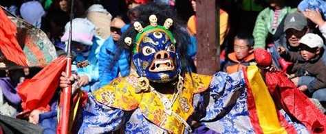
The Cham (Masked Dances)
On the sixteenth day, are the dances that worship Phakpa Chenrezig. Each dance relates to a pujah done during the previous days.
The dances come from when Guru Rinpoche blessed Samye, the first monastery in Tibet. He pretended to be his favorite god by imitating its body and danced the blessing. Since then, some lamas think they will see these dances in Dewachen. Cham means sacred dance.
There are many gods in Tibet who used to wear these costumes. The black hats were the costumes of the Phembu gods. Then it became the dress of the original ngagpas (married lamas) when they did the thu-duph, a powerful pujah. Later it became the dancing dress of monks and ngagpas.
Rol-cham is the grand entrance of the monks wearing yellow hats and playing pujah instruments.
Serkyem is the first dance with dancers wearing costumes and black hats. This dance invokes tse gyepa (improving one's life, longevity, appearance health and intelligence), whang (providing spiritual power) and thub (the ability to fight bad spirits). The black hats represent ngagpa or Vajrayana priest capable of using spiritual powers.
Ging-cham is the dance by four attendants of Dorje Trollo. Two females carry nga (drums) and two males carry buk-chal (cymbals). They make offerings of tsog to Dorje Trollo.
Guru Dorje Trollo is a single masked dancer representing one of the fierce forms of Guru Rinpoche. He is preceded by monks playing instruments.
Nga-cham originated as Guru Rinpoche's dance when he blessed Samye gompa. The six dancers wear golden hats with peacock feathers and carry drums. In the past Tibetan officials wore the golden hat.
Durdag-cham is a complicated dance with two skeletons and two black-hat dancers. The skeletons carry a dough figure, representing evil, on a rope between them. It is symbolically destroyed by the black hat dancers.
Mi Tsering, the long life man, is a comic interlude.
The Maha-kala dance has eight characters all representing different deities: Tseringma (the main long-life sister), Maha-kala (the protector), and Mahadeva (Lhachen Whangchuk) are the main ones.
Zurra-rakye, a local protective god, carries a goat horn and long stick. Two minaks (attendants) accompany him. He is the guardian of Khenpalung, a hidden valley that has not yet been opened.
Khaadro are five female deities of wisdom often referred to as the sky dancers.
Thog-den makes an appearance in the second comic dance. This is the only dance with any speaking as he jokes with his assistant or the crowd and teaches religion.
Lhagma has the purpose of getting rid of left over rilbu, long life pills. Two masked dancers, one male and one female, perform this task.
Ti-jum is a cham where four masked dancers carry knives.
Zor-cham is a ritual exorcism in which dancers wearing black-hats carry small torma, lok-par, that signify evil. The dancers throw out these torma.
Then-cham also functions to get rid of evil. Half of the dancers wear black hats, the other half masks.
Log-cham is the finale with some dancers from each cham.
For the different gods, there are different ways of praying, chanting or dancing that help make the gods closer to the dancer, and eventually a part of him, helping everyone. Sometimes from prayers, deep thinking or meditation, the same happens. This makes the country peaceful and in the future will help everyone.
Source: Stories and Customs of the SHERPAS As told by Ngawang Tenzin Zangbu Abbot of Tengboche Monastery.
Edited by
Frances Klatzel
Day 1:
Arrival KTM – transfers to hotel- afternoon- trek briefing at hotel
Day 2:
IN KTM - Sightseeing – Patan and Monkey temple
Day 3:
30 minutes flight to Lukla – 4 hrs trek to Chuman. (2840m)
Day 4:
Trek to Namche – (3440m)
Day 5:
Trek to Thame – (3820m)
Day 6:
Visit Thame Monastery trek to Targa – Short day – acclimatization
Day 7:
Lungde – short day – acclimatization
Day 8:
Early morning start with Pack lunch for Gokyo – Cross Renjo Pass (5340m) – decent down to Gokyo (4790m) - Long day
Day 9:
Visit Gokyo Ri – Return to Na (4550m)
Day 10:
Phortse (3810m)
Day 11:
Tyangboche via Pangboche (3860m)
Day 14:
Namche
Day 15:
Lukla
Day 16:
KTM - Fly Out
Day 17:
In KTM
Day 18:
Depart
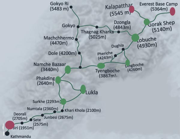
Khumbu Everest Trek


Day 01 CHUMOA (9000'/2743m)
The flight from Kathmandu to Lukla has to be one of the most spectacular in the World. Twin Otters fly this route of contrasting with the snowline of the Himalayan range to the north and rugged foothills of Nepal immediately below and stretching away to the south. The landing at Lukla airstrip (9184'/2800m) adds considerably to the general excitement and expectation. After a sort out and a cup of tea the trail leads northwest and descends to the river at Phakding (8698'/2652m). The trail leads to the attractive fir forested areas near the entrance to the Sagarmatha (Everest) National Park where there are good campsite to be found around Chumoa and Jorsale. Time 5 and half hours.
Day 02 NAMCHE (11300'/3445m)
Another good reason for the longish first day is that the plod up the steep hill to Namche is better done when fresh and fit in the early morning. Near the halfway point up the hill views of Everest (29028'/8848m) and Lhotse (27938'/8516m) come into sight. Namche is the most prosperous and largest town in Khumbu. A traditional trading center the Bazar is held every Saturday. The wares on display include grains and vegetables, tennis shoes and trinkets as well as hand woven aprons and Tibetan boots. Thamserku (21806'/6648m) and Kwangde (20417'/6224m) loom to the east and west, and the sacred mountain Khumbila (18729'/5707m) dominates the skyline to the north behind the village. Time: 4 hours.
Day 03 THAME (12467'/3801m)
Traverse westwards with views of Kwangde (20806'/6343m) and the waterfalls cascading off its flanks. Follow Bhote Kosi as trail side- hills high on its bank through yellow and white rhododendron forest (in full bloom in May). Cross-river, look back down Valley for beautiful views of Thamserku (21806'/6648m) and Kusum Kangru (20896'/6370m). Climb up through rhododendron forest to pasture lands in front of Thame. This is the birthplace of Tenzing Norgey, the first Sherpa ever to climb Mt. Everest. Camp in meadows at the edge of village. An hour's climb to the cliff side monastery is of great interest. From here, the trekkers can continue above the village, then climb across the ridge to view the route to the Nangpa La, a pass to Tibet frequently used by the Sherpas and their yaks during the monsoon. Time: 6 hours. Note: The trip to the monastery is generally better done in the early morning of day 4.
Day 04 KHUMJUNG (12434'/3791m)
Walk back down the valley by way of Thamo, a hillside nunnery. Take the high trail, which bypasses Namche and drops into Khumjung. This valley is one of the most beautiful in Khumbu. The Sherpas may extend their hospitality and offer a teatime visit to one of their houses - an experience. Time: 6 hours.
Day 05 TENGBOCHE (12670'/3863m)
The trail descends from Khumjung with Chortens forming a dramatic view of Ama Dablam (21964'/6696m) and Kangtaiga (22235'/5779m) flanked by the towering heights of Sagarmatha (the Nepalese name for Everest), Lhotse and Nuptse. Descend through moss covered rhododendron forest, watching for blood pheasant and the Impeyan pheasant in the under growth. Cross the Dudh Kosi at Phungithanga and climb through rhododendron forest to the saddle at the top of the hill. Here lies Thyangboche the main monastery of the Khumbu area. The views from here are unforgettable. Tengboche lies at the base of Kangtaiga and the spur of this ridge affords panoramic views of the main peaks of Khumbu including Everest, Lhotse and Ama Dablam. Time: 5 hours.
Day 06 DINGBOCHE (14150'/4412m)
The descent from Thyangboche leads through fir and rhododendron - beautiful country up to the spectacular little bridge across the Imja Khola leading to the village of Pangboche. The ascent continues through more open country now as the tree line is left behind. Down and across the river again leaving the main Everest trail and gradually climbing up to the attractive village of Dingboche possibly the highest spot in the world where barely is grown. The Himalayan Rescue Association has an aid post just over the hill at Pheriche. Time: 6 hours.
Day 07 DINGBOCHE
A day walk up to Chukung is highly recommended. The route gradually extends to the few scattered stone huts that make up the settlement. To the south are ever changing views of Ama Dablam and to the north the massive wall on the Nuptse ridge and the south face of Lhotse. The energetic an early start can climb Chukung Ri. Time: 5 hours (return trip).
Day 08 LOBUCHE (16175'/4931m)
The route traverses across the slopes over a ridge staying above the village of Pheriche. It joins the main trail below Thugla. There are fine views of Cholatse (21129'/6442m) across the valley. Turning east the trail climbs steeply up the terminal moraine of the Khumbu glacier. Once on top it is a steady plod along the side of the moraine. Stark and rugged beauty almost creates a moonscape. Campsite at Lobuje, a windswept collection of huts tucked in a narrow meadow between the glacier and Lobuje peak (20192'/6156m). Tawache and Nuptse are particularly spectacular from Lobuje, towering almost 2 kilometers directly overhead. Time: 5 hours.
Day 09 LOBUCHE
Early start essential. Travel along the Khumbu Glacier through jumbled moraine and shattered rock. Climb Kala Pattar (18188'/5545m) for views of the giants of the earth Pumori (23436'/7145m), Everest, the Tibetan peak Changtse (24764'/4501m) Nuptse, Lhotse and countless other needles and snow fluted ridges. Time: 6 hours. A trip to the actual Base Camp of Everest is usually omitted. Views are obstructed by the Khumbu ice fall. Unless an expedition is actually at base camp a route can be difficult to find.
Day 10 PHORTSE (12618'/3847m)
Descend gradually all morning. Pass through Pangboche. Stay high on the west bank of the river to the Sherpa village of Phortse, which lies on the lower southern flank of Tawache, directly across the valley from Thyangboche. A long day. Time: 7 hours.
Day 11 KHUNDE/KHUMJUNG
Descend through forest to the Dudh Kosi. A very pretty crossing point leads to a steady climb to a Chorten offering wonderful views back across the valley to Phortse, Thyangboche and their surrounding mountains. A traverse leads to a classic descent down a giant rock pathway hewn out of the mountain side. A plod up the valley leads back to the twin villages. Time: 5 hours.
Day 12 MONJO/JORSALE
The route home leads back through Namche and off down the hill. There are some nice campsites opposite to the National park boundary. Time: 5 hours.
Day 13 LUKLA (9200'/2804m)
From here the walk to Lukla takes about five hours of which the last one and half are rather surprisingly hard work.
Day 14
One of the most thrilling take-off in the world wings the Twin Otter high above the Dudh Koshi for the 40 minutes flight back to Kathmandu.
Khumbu - Everest Imja Tse Climb

DAY 01 CHUMOA (9000'/2743m)
The flight from Kathmandu to Lukla has to be one of the most spectacular in the World. Twin Otters fly this route of contrasting with the snowline of the Himalayan range to the north and rugged foothills of Nepal immediately below and stretching away to the south. The landing at Lukla airstrip (9184'/2800m) adds considerably to the general excitement and expectation. After a sort out and a cup of tea the trail leads northwest and descends to the river at Phakding (8698'/2652m). The trail leads to the attractive fir forested areas near the entrance to the Sagarmatha (Everest) National Park where there are good campsite to be found around Chumoa and Jorsale. Time 5 and half hours.
DAY 02 NAMCHE (11300'/3445m)
Another good reason for the longish first day is that the plod up the steep hill to Namche is better done when fresh and fit in the early morning. Near the halfway point up the hill views of Everest (29028'/8848m) and Lhotse (27938'/8516m) come into sight. Namche is the most prosperous and largest town in Khumbu. A traditional trading center the Bazar is held every Saturday. The wares on display include grains and vegetables, tennis shoes and trinkets as well as hand woven aprons and Tibetan boots. Thamserku (21806'/6648m) and Kwangde (20417'/6224m) loom to the east and west, and the sacred mountain Khumbila (18729'/5707m) dominates the skyline to the north behind the village. Time: 4 hours.
DAY 03 THAME (12467'/3801m)
Traverse westwards with views of Kwangde (20806'/6343m) and the waterfalls cascading off its flanks. Follow Bhote Kosi as trail side- hills high on its bank through yellow and white rhododendron forest (in full bloom in May). Cross-river, look back down Valley for beautiful views of Thamserku (21806'/6648m) and Kusum Kangru (20896'/6370m). Climb up through rhododendron forest to pasture lands in front of Thame. This is the birthplace of Tenzing Norgey, the first Sherpa ever to climb Mt. Everest. Camp in meadows at the edge of village. An hour's climb to the cliff side monastery is of great interest. From here, the trekkers can continue above the village, and then climb across the ridge to view the route to the Nangpa La, a pass to Tibet frequently used by the Sherpas and their yaks during the monsoon. Time: 6 hours. Note: The trip to the monastery is generally better done in the early morning of day 4.
DAY 04 KHUMJUNG (12434'/3791m)
Walk back down the valley by way of Thamo, a hillside nunnery. Take the high trail, which bypasses Namche and drops into Khumjung. This valley is one of the most beautiful in Khumbu. The Sherpas may extend their hospitality and offer a teatime visit to one of their houses - an experience. Time: 6 hours.
DAY 05 TENGBOCHE (12670'/3863m)
The trail descends from Khumjung with Chortens forming a dramatic view of Ama Dablam (21964'/6696m) and Kangtaiga (22235'/5779m) flanked by the towering heights of Sagarmatha (the Nepalese name for Everest), Lhotse and Nuptse. Descend through moss covered rhododendron forest, watching for blood pheasant and the Impeyan pheasant in the under growth. Cross the Dudh Kosi at Phungithanga and climb through rhododendron forest to the saddle at the top of the hill. Here lies Thyangboche the main monastery of the Khumbu area. The views from here are unforgettable. Tengboche lies at the base of Kangtaiga and the spur of this ridge affords panoramic views of the main peaks of Khumbu including Everest, Lhotse and Ama Dablam. Time: 5 hours.
DAY 06 DINGBOCHE (14150'/4412m)
The descent from Thyangboche leads through fir and rhododendron - beautiful country up to the spectacular little bridge across the Imja Khola leading to the village of Pangboche. The ascent continues through more open country now as the tree line is left behind. Down and across the river again leaving the main Everest trail and gradually climbing up to the attractive village of Dingboche possibly the highest spot in the world where barely is grown. The Himalayan Rescue Association has an aid post just over the hill at Pheriche. Time: 6 hours.
DAY 07 DINGBOCHE
A day walk up to Chukung is highly recommended. The route gradually extends to the few scattered stone huts that make up the settlement. To the south are ever changing views of Ama Dablam and to the north the massive wall on the Nuptse ridge and the south face of Lhotse. The energetic an early start can climb Chukung Ri. Time: 5 hours (return trip).
DAY 08 LOBUCHE (16175'/4931m)
The route traverses across the slopes over a ridge staying above the village of Pheriche. It joins the main trail below Thugla. There are fine views of Cholatse (21129'/6442m) across the valley. Turning east the trail climbs steeply up the terminal moraine of the Khumbu glacier. Once on top it is a steady plod along the side of the moraine. Stark and rugged beauty almost creates a moonscape. Campsite at Lobuje, a windswept collection of huts tucked in a narrow meadow between the glacier and Lobuje peak (20192'/6156m). Tawache and Nuptse are particularly spectacular from Lobuje, towering almost 2 kilometers directly overhead. Time: 5 hours.
DAY 09 LOBUCHE
Early start essential. Travel along the Khumbu Glacier through jumbled moraine and shattered rock. Climb Kala Pattar (18188'/5545m) for views of the giants of the earth Pumori (23436'/7145m), Everest, the Tibetan peak Changtse (24764'/4501m) Nuptse, Lhotse and countless other needles and snow fluted ridges. Time: 6 hours. A trip to the actual Base Camp of Everest is usually omitted. Views are obstructed by the Khumbu ice fall. Unless an expedition is actually at base camp a route can be difficult to find.
DAY 10
Khongmala
DAY 11
Imja Tse Base Camp
DAY 12 and 13
Climb Imja Tse Chukhung
DAY 14
Pangboche
DAY 15 KHUMJUNG
Descend through forest to the Dudh Kosi. A very pretty crossing point leads to a steady climb to a Chorten offering wonderful views back across the valley to Phortse, Thyangboche and their surrounding mountains. A traverse leads to a classic descent down a giant rock pathway hewn out of the mountain side. A plod up the valley leads back to the twin villages. Time: 5 hours.
DAY 16 MONJO/JORSALE
The route home leads back through Namche and off down the hill. There are some nice campsites opposite to the National park boundary. Time: 5 hours.
DAY 17 LUKLA (9200'/2804m)
From here the walk to Lukla takes about five hours of which the last one and half are rather surprisingly hard work. DAY 18 One of the most thrilling take-off in the world wings the Twin Otter high above the Dudh Kosi for the 40 minutes flight back to Kathmandu.
Kanchanjunga Trek

Still unspoiled, the area beyond Taplejung offers magnificient treks, both to the north and the south base camps of the giant Kanchanjunga range, myriad glacier system, high pass crossing and vast unspoiled foothills.
The highest point reached is 5143 meters, the north base camp. Ghunsa village is the last permanent settlement for local inhabitants.
With the flight in and out of Suketar (Taplejung) it can be 16- day trekking, with the drive both ways 18 – 20 days.
TREK GRADING: D

Detailed Itinerary
Day 01:
Fly to Biratnagar and stay there in a hotel. Take a day tour around the town.
Day 02 MITLUNG (920m):
Fly to Suketar (Taplejung) a 35 minute flight, meet guides, camp staff, porters and begin walk. After 5 hrs. walk, down hill, Mitlung is reached, a small village with 5 houses. Camp below the village.
Day 03 CHIRUWA (1150m):
The trail passes along the Tamur river for approximately ¾ hours through some beautiful rock gorges and the occasional small Buddhist village. Camp beyond Chiruwa after passing through bush forest where abundant bird life is evident.
Day 04 SIKATHUM (1640m):
A relatively easy walk up the river, pass the well kept village of Tapethik, to a lunch spot after 2 ½ hours. The trail rises and falls more steeply after lunch for 2 hours, until the riverside campsite at Sikathum is reached after crossing the rivers Simbua Khola and Ghunsa Khola.
Day 05 AMJILASA (2500m):
A steep and long climb up a trail that is quite rough and exposed in places for approximately 5 hours. Good views of valley and river below and Himalayan peaks in the distance. Several open Yak grazing pastures exist here and clear side streams provide good water supply.
Day 06 KYAPRA (GYAPLA) (2730m):
A moderate ascent along the ridge for approximately 1 hour and then a steep decent to Tangep. From here it is hike along the river banks through densely forested hillsides – (bamboo, fir and scattered rhododendron). The river drops steely with many waterfalls and crystal clear pools. Climb up to green pastures just beyond a group of Buddhist stone houses at Kyapra (Gyapla).
Day 07 GHUNSA (3430m):
Generally along the river the trail gently undulates with a few steep uphill portions. Pass through the village of Phele and perhaps visit a Buddhist Gompa near to the village – much Tibetan art is evident as are the villagers weaving Tibetan rugs. Ghunsa is a large Tibetan community of stone houses and tidy small farms. Camp above Ghunsa.
Day 08 SHIELELE (4290m):
Walk up the ridgeline for about 2 hours, then cross Tamo La – Shielele for camp – walk about 6 hours.
Day 09 TSERAM (3870m):
Climb to the ridge then cross Mirgin La. After the pass, another 2 ½ hours Tseram is reached for camp.
Day 10 RAMZE (4580m):
The trail from Tseram is a gentle uphill one which goes through the woods, cross streams. Leaving Lapsang, continue on and pass a small pond. After walking about 4 ½ hours Ramze is reached.
Day 11 DORONDIN (2990m):
Start early for the hike up to the Waktang for views. Only by going to this point can you see the entire peaks of Kanchanjunga. Return to Dorondin for camp by a stream.
Day 12 AMJE KHOLA (2340m):
The day is about 5 ½ hours walk through thick forest and meadows.
Day 13 MAMANGKHE (1420m):
6 hours walk.
Day 14 KUNJARI (1675m):
near Pakhola – 6 hours walk.
Day 15 SUKETAR (2360m):
5 ½ hours walk.
Day 16 :
Fly to Biratnagar and Kathmandu.
Island Peak(Imja Tse) Climb

High Camp(5600m):
The route from Chukung leads fairly steeply away climbing south then turning east up the main line of the valley for 30 - 40 minutes. It then winds along or below the southern flank of the moraine from the Lhotse Glacier. Another 20 - 45 minutes of pleasant walking along a streamside leads to what we call 'Big Rock'. The route to the Amphu Lapcha lies to the southeast after a total of 1-¾ hours. A crisscross route through the Imja and Lhotse Glacier moraines leads to a wide valley flanking the SW of Island Peak. An hour walk leads to the base camp at 5050m. A rather unattractive spot with no views and poor water supply. We advise a push up from here to the high camp at 5600m. A steep scramble up round and provides just enough space for several tents.
Climb:
The climb starts with a one-hour scramble across a rock gully and then up the right hand rim of the gully onto broken slate and rock to the snow line. After fitting crampons the route leads up a small snow bank down across gully threatened by overhanging ice, before starting a gentle ascent up a wide glacier basin. The route then turns more steeply to the north to the foot of exposed rock scree. This leads to the hardest section of the route. If climbing with the Sherpas, they will almost certainly put in fixed ropes up the first 60 - 70 meters or so across exposed scree and broken snow/ice field. The route then leads more or less straight up through this mini snow/ice forest to the summit ridge. The last 20 meters or so should also be protected by fixed rope. The ridge offers fine 360-degree views of Makalu, Ama Dablam, Baruntse, Mera Peak (Hongu) and the vast southern flanks of Nuptse and Lhotse. (Snow line to ridge - 3 hours). A final 300m. plus along and up and down the summit ridge finally brings one to the southern summit (6100m.). Total time high camp to summit - approx. 4 hours.
Note:
Conditions and timing may vary according to the season. These notes were made after a successful climb by some of our staff in April 2007. The return follows the same route and we recommend that if the groups are feeling up to it then return back to Chukung.
Kanchanjunga Base Camp Trek

Still unspoiled, the area beyond Taplejung offers magnificient treks, both to the north and the south base camps of the giant Kanchanjunga range, myriad glacier system, high pass crossing and vast unspoiled foothills.
The highest point reached is 5143 meters, the north base camp. Ghunsa village is the last permanent settlement for local inhabitants.
With the flight in and out of Suketar (Taplejung) it can be 16- day trekking, with the drive both ways 18 – 20 days.
TREK GRADING: D
Detailed Itinerary
Day 01 BASANTPUR (9000'/2744m):
Fly from Kathmandu to Biratnagar. The bus drive to via Dharan, Dhankuta and Hile begins in the Terai. But soon starts winding up steeply taking one through rich agricultural countryside. Basantpur is a thriving town with a busy weekly market.
Day 02 CHOWKI (9020'/2750m):
Moderate uphill walking for 1 ½ hours to the Milke Danda ridge through dense semi forests of rhododendron and conifer trees; mostly covered in hazing moss. Beautiful views of the terraced hills rolling down to the valley far below. The hills are dotted with agricultural villages. The route continues along the ridge and then descends for 1-½ hours to Chowki where distant views of Kanchanjunga and other big peaks maybe obtained. Total 5 hours.
Day 03 GUPHA POKHARI (9775'/2980m):
A relatively easy 3 ½ hour walk along the ridge from Chowki through enchanting forest of fir, rhododendron and bamboo, past small ponds and scattered houses to the village of Gupha pokhari where there are small stoned houses, Tibetan prayer flags, mixed Hindu (Rai and Limbu) and Buddhist culture.
Day 04 GORJA GAON (6550'/2000m):
A steep trail which takes one both up and down and at times can be rough and difficult – approx. 1 ½ hours to the top of the ridge at 9700'/2957m. Views down into the Tamur valley are obtaining from here. A descent for 3 hours through rich terraced hillside and beautiful plastered houses with thatched roofs to the village of Gorja Gaon.
Day 05 Above DOVAN (2460'/730m):
A steep descent for 4 hours on a rocky trail through rich terraced agricultural hills, past scattered bush and tall stands of 'lumur' bamboo to the town of Dovan which lies on the Tamur river. Across a small bridge and camp near to the river where there are good pools for bathing. The afternoon maybe spent relaxing.
Day 06 MITLUNG (3182'/920m):
The trail is now much narrower than before, and quite rough in parts. It goes up and down quite steeply following the river through agricultural field for three hours before the lunch spot is reached. After lunch, the trail continues with steep ups and downs, including a half hour ascent up a landslip, over large boulders and fast flowing streams, eventually past the village of Mitlung to a riverside camp (2 hours).
Day 07 CHIRUWA (4428'/1150m):
The trail passes along the Tamur river for approx. 3/4 hours through some beautiful rock gorges and the occasional small Buddhist village. Camp beyond Chiruwa after passing through bush forest where abundant bird life is evident.
Day 08 SIKATHUM (6000'/1640m):
A relatively easy walk up the river, pass the well kept village of Tapethik to a lunch spot after 2 ½ hours. The trail rises and falls more steeply after lunch for 2 hours, until the riverside campsite at Sikathum is reached after crossing the rivers Simbua Khola and Ghunsa Khola.
Day 09 AMJILHASA (7872'/2500m):
A steep and long climb up a trail that is quite rough and exposed in places for approx. 5 hours. Good views of valley and river below and Himalayan peaks in the distance. Several open Yak grazing pastures exist here and clear side streams provide good water supply.
Day 10 KYAPRA (9250'/2730m):
A moderate ascent along the ridge for approx. 1 hour and then a steep descent to Tangep. From here it is a hike along the riverbanks through densely forested hillsides – (bamboo, fir and scattered rhododendron). The river drops steeply with many waterfalls and crystal clear pools. Climb up to green pastures just beyond a group of Buddhist stone houses at Kyapra (Gyapla).
Day 11 GHUNSA (11414'/3430m):
Generally along the river the trail gently undulates with a few steep uphill portions. Pass through the village of Phele and perhaps visit a Buddhist Gompa near to the village – much Tibetan art is evident as are the villagers weaving Tibetan rugs. Ghunsa is a large Tibetan community of stone houses and tidy small farms. Camp above Ghunsa.
Day 12 KAMBACHEN (13120'/4040m):
A fairly trail that climbs up alongside the river. Several magnificent waterfalls are encountered along the trail. Yak herders maybe met along the trail. Excellent views of Jannu and other high, snow and glacier juniper. Camp near to aside steam. Total time approx. 5 hours.
Day 13 KAMBACHEN:
A rest day is taken here to enable time to relax, bathe or take a day walk.
Day 14 LHANAK (15416'/4790m):
The trail follows above river for about 1 hour and then heading east drops down to the river. Walking from here is on large boulders that lead to the terminal moraine of the Kanchanjunga glacier. The lateral moraine is then followed with incredible views of the Kanchanjunga glacier and nearby peaks. Total time approx. 3 hours.
Day 15 PANG PEMA (16613'/5141m):
The trail continues along the Kanchanjunga glacier with a moderate to slow ascent with excellent views. Afternoon free for exploration.
Day 16 KAMBACHEN:
Descent 4-5 hours back to Kambachen.
Day 17 PHELE:
Descent 4-5 hours to Phele.
Day 18 AMJILHASA (7872'/2500m):
Ups and downs along the Ghunsa river, past Kyapra and then descend on to Amjilhasa.
Day 19 CHIRUWA (4428'/1150m):
Continue following the river back to Chiruwa.
Day 20 MITLUNG (3182'/920m):
Return back to Mitlung.
Day 21 GORJA GAON (6550'/1997m):
Return back to Gorja Gaon.
Day 22 CHOWKI (9020'/2750m):
A long days return trek to Chauki.
Day 23 BASANTPUR:
A steep climb at first and last views of the high mountains before dropping down, with the trail becoming wider and busier to the campsite at Basantpur.
Day 24 DHARAN:
Take a bus to Dharan (approx. 5 hours).
Day 25:
An hour or so drive from Dharan to the airport at Biratnagar and then a 40-minute flight to Kathmandu.
Gokyo Lake - Cho La Crossing - Kalapathar


Day 01 CHUMOA (9000'/2743m):
The flight from Kathmandu to Lukla has to be one of the most spectacular in the world. Twin Otters / Don Air fly this route of contrasting country with the snowline of the Himalayan range to the north and with the rugged foothills of Nepal below and stretching away to the south. The landing at Lukla airstrip (9184'/2880m) adds considerably to the general excitement and expectation. After a sort out and a cup of tea the trail leads northwest and descends to the river at Phakding (8698'/2652m).
Note :
On 5 August 1985 as avalanche of ice and rock falling into and ice lake above the village of Thame caused the lake to burst. The resulting flood greatly affected the Bhote Koshi Valley destroying bridges and the partially built hydro scheme below Thame. It also destroyed all the other bridges and some of the route down the Dudh Koshi. HowevIt It is worth progressing on along the new route to the attractive fir forested areas near the entrance to the Sagarmatha (Everest) National Park where there are good campsites to be found around Chumoa and Jorsale and Lodges. Time 5 ½ hours.
Day 02 NAMCHE (11300'/3440m):
Another good reason for the longish first day is that the steep hill to Namche is better done when fresh and fit in the early morning. Near the halfway point up the hill views of Everest (29028'/8848m) and Lhotse (27916'/8516m) come into sight. This prosperous town is the largest in Khumbu. A traditional trading center the Bazaar is held every Saturday. The wares on display include grains and vegetables, tennis shoes and trinkets as well as hand woven aprons and Tibetan boots. Thamserku (21728'/6623m) and Kongde (20298'/6187m) loom to the east and west, and the sacred mountain Khumbila (18729'/5707m) dominates the skyline behind the village. Time 6 hours.
Day 03 THAME (12467'/3820m):
Traverse westwards with views of Kongde and the waterfalls cascading off its flanks. Follow Bhote Koshi as trailside hills on its bank through yellow and white rhododendron forest (in full bloom in May). Cross-river, look back down valley for beautiful views of Thamserku and Kusum Kanguru (20896'/6370m). Climb up through rhododendron forest to pasture lands in front of Thame. This is the home of Tenzing Norgey, the first Sherpa ever to climb Mt. Everest. Camp in meadows at edge of village. An hour's climb to the Cliffside monastery is of great interest. From here, the trekkers can side hill above the village, then climb across the ridge to view the route to the Nangpa La, a pass to Tibet frequently used by the Sherpas and their Yaks during the monsoon. Time 6 hours.
Day 04 KHUNDE/KHUMJUNG (21434'/3991m):
Walk back down the valley by way of Thamo, where there is a hillside nunnery. Take the high trail, which bypasses Namche and drops into Khumjung. This village is one of the most beautiful in the Khumbu. It's symmetrically laid out stone dwelling houses the families of many famous Sherpas. The Sherpas may extend their hospitality and offer a teatime visit to one of their houses.
Day 05 DOLE (13251'/4040m):
The trail leads down past the school and Khumjung villages before dropping into rhododendron scrub forest and then towards an impregnable looking rock wall on the north side of the valley. A giant's causeway of granite steps makes an incredible route up this face before the trail emerges on high grazing ground. One hour further and there is a very charming Chorten, which poses naturally as the foreground for wonderful photos across the valley to Ama Dablam (22487'/6856m), Kangtega (22240'/6779m) and Thamserku standing high above the meadowlands of Thyangboche monastery. The trail drops quickly nearly all the way to the Dudh Koshi before leaving the route to Phortse. There is good lunch spot set amidst birch and rhododendron. Afterwards a stiff but attractive climb leads to Dole which lies on the tree line. Time 6 hours.
Day 06 FANGA (14694'/4400m):
The first hour involves steady climbing before the trail contours to Luza (14333'/4370m) – small grazing areas with potato fields and inhabited year round. After lunch, a short uphill then leads down to the Fanga valley. Time 5 ½ hours.
Day 07 GOKYO LAKES (15580'/4750m):
A steady climb soon leads to the first of the Gokyo Lakes and the main lake and camping. Note: Day 07 and 08 are both short days to allow additional time for acclimatization.
Day 08 GOKYO RI (17984'/5357m) and return:
Unlike the Kala Pattar hill from Lobuche the foot of Gokyo Ri lies five minutes away across a stream that feeds the lake. A two or three hour climbs leads to the summit from where the views are well worth all the effort involved. Everest showing more of its northern flank then from Kala Pattar, with Makalu (27798'/8463m) farther to the east. To the north Cho Oyu (26741'/8153m) all round snows, ice glacial moraines and the giants of the world.
Day 09 Above CHYOGIMA (16531'/5040m):
The trail initially leads back south before leaving the main route and a short climb leads to the crossing of the jumbled moraine of the Ngo Zumba Glacier. Lunch at Thagnak. Hard scrambling until a high camp tucked in below the pass is reached. Time 5 ½ hours.
Day 10 DZONGLA (15885'/4830m):
An early start is recommended and the route likes over large uncomfortable broken and scree before starting up the slab rock of the pass itself. Dependant on the time of year mixed snow and rocks leads to the summit snow field of the Chyogima La (Pass) 17777'/5330m. The descent starts gently before steeping onto rock and snow and broken ground leads to the few stone huts that make up Dzongla. Time 4 ½ hours.
Day 11 LOBUCHE (16175'/4930m):
An ill-defined track traverses across to join the main trail coming up from Pheriche. There are beautiful views of Cho Latse (21129'/6442m) back to the west. A steep ascent leads to the terminal moraine of the Khumbu Galcier. The stark and rugged beauty creates almost a moonscape. The campsite at Lobuche is tucked into a windswept side valley with a huddle of herders' huts and teahouses. Tawache and Nuptse are particularly spectacular from Lobuche. Time 4 hours.
Day 12 LOBUCHE:
Early start essential. Travel along the Khumbu Glacier through jumbled moraine and shattered rock. Climb Kala Pattar (18188'/5545m) for views of the giants of the earth. Pumori (23436'/7145m), Everest and Tibetan Peak Changtse (24764'/4501m), Nuptse, Lhotse and countless other needles and snow fluted ridges. Time 8 hours. A trip to the actual Base camp of Everest is usually omitted. The Khumbu icefall obstructs views and the base camp area is littered with debris from years of climbing expeditions to Everest, and unless an Expedition is actually at base camp a route can be difficult to find
Day 13 DINGBOCHE (14268'/4260m):
Back down the moraine and gradually losing altitude the stone windswept village of Pheriche is reached where the Himalayan Rescue Assoviation (HRA) has its Aid Post. A climb over the ridge past Chortens and Mani Walls leads to the Chukung valley and the prosperous village of Dingboche where with their own irrigation scheme they grow barley, possibly the highest altitude in the world at which this crops is grown.
Day 14 CHUKUNG (15514'/4730m):
The three or four scattered stone and slate huts provide in the summer months the base for good high grazing but during the rest of the year some of the huts are run as teahouses for trekkers. The trail from Dingboche is ill defined but follows the main line of the valley ascending gently with Ama Dablam and the high ridges leading to the difficult Amphu Lapcha Pass (18958'/5780m) on the right and massive Southern flanks of Nuptse on the left. It takes about two hours up to Chukung and an early start from Dingboche would allow plenty of time for a climb of Chukung Ri (16541'/5043m) across the mixed rubble and grassland lying just north of the houses, and from where the famous south face of Lhotse can be clearly seen. Island Peak (20299'/6189m) the most popular of the 'Trekking Peaks' stand by itself at the east end of the valley.
Day 15 TENGBOCHE (12683'/3867m):
Having been constantly at altitudes above 14000' most trekkers welcome the thought of returning to warmer, softer climbs and the days walk to Tengboche is a delightful way of doing so. Back down to Dingboche and through the long walled paths of the village, then a gradual ascent along the flanks of the hill below the village before a steep drop down to the Dudh Koshi. Above, the route rejoins the main trail coming down from Pheriche. Lunch in the meadowlands of Orsho or Shomare. Then through the important village of Pangboche (13070'/3985m) the Yeti scalp, which traveled the world in the 60s, is housed at the monastery high on the hillside here. This monastery lies more on the route to phortse and is not easily reached from the lower trail. As spectacular little bridge over the river leads into fir and rhododendron forest and a lovely afternoon's walk before the short climb to Thyangboche.
Day 16 NAMCHE:
The descent to the Imja Khola and the small village of Phunki (10660'/3250m) with its water-powered prayer wheels takes about 1 ½ hours. The original Himalayan Trust Bridge built by Sir Edmund Hillary was swept away some years ago when a flood caused by the build up of water behind a massive landslide on the flanks of Ama Dablam surged down the valley. A more temporary structure is now in place and leads to the climb up towards Khumjung. Good lunch spots are available as the gradient lessens. After lunch there is no need to return to Namche via Khumjung as a path around the eastern flanks of the hills offers easy and delightful walking back to Namche.
Day 17 LUKLA (9184'/2800m):
Most people leave Namche and head down hill with a heavy-heart. There is something about the setting, the villages and the people of the high Khumbu hills and valleys and it is sad to leave them. A long day back through Phakding and then the deceptively long hard climb leading up to Lukla. Our campsite and house are well located and offer a good final resting spot for (hopefully) the one night stay before the early morning departure.
Day 18:
Flights to Kathmandu operate during the mornings before winds above the Dudh Koshi build up. The take-off is as spectacular as the earlier landing.


